Needles History by Maggie McShan
Needles, founded in 1883, is one of the oldest living communities on the Colorado River, rich in history and promise for the future. The fabric of it’s past is intricately woven of influences of the river, the railroad, Old Trails Highway (later Route 66), the Mojave Indian Tribe, and pre-history – evidence of which abounds on the land. Perhaps most of all it has been influenced by it’s climate… hot summers offset by mild and wonderful winters.
A backward glance into the misty past is necessary to set the stage for defining Needles as a unique community and for relating how she happened to be founded in the first place.
Mojave Indians lived in this valley long before white people ever set foot on the land. Descendents of these early people still live here today and are called the Fort Mojave Indian Tribe. How long the Mojaves were in residence here is not known but the archaeological record shows that early people were here thousands of years ago. Ancient petroglyph, pictographs, intaglios, old trails and stone work sites bear witness of those who came before us. These features are of much interest to historians both local and throughout the world, and they especially intrigue the interest of visitors.
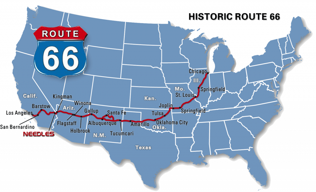
Arrival of the railroad at the Colorado River in 1883 actually caused the founding of the town. The new settlement was named “The Needles”, a namesake of the sharp peaks at the southerly end of the valley. The peaks themselves had been named by Lt. Amiel Weeks Whipple when he started the whole thing by heading the government survey for a railroad in 1854. The first bridge across this part of the Colorado River was built about 1883, and often washed away. The railroad was rerouted to Topock, and the Old Red Rock Cantilever Bridge was built in 1890. At first people mostly traveled to and from Needles by rail, then Old Trails Highway, later called Route 66, came into being. Its approximate route is now followed by Interstate 40. A group of local citizens worked hard to keep the freeway from missing Needles for many years, and their work contributed greatly to the town’s future. Some of the significant events affecting the town have been the building of the dams along the Colorado River and dredging of the river by the Bureau of Reclamation in the early 1950s, ending the long history of flooding from “hill to hill” each spring. Dredging drained the valley lands so they became suitable for agriculture and housing. The water became clear and suitable for recreation. Thus, two new industries came to the valley, agriculture and recreation. Needles has also been the scene of two major military maneuvers, General Patton’s Army during World War II, and Desert Strike maneuvers in the mid- 1960s.
Today Needles provides many attractions to its winter and summer visitors. The East Mojave National Scenic Area offers a vast variety of desert scenes and wildlife. The Colorado River has some of the finest boating and fishing possibilities found anywhere. The Needles Municipal Golf Course, which overlooks the river, is a professional 18 hole course with a driving range, golf carts and pro shop. The Topock Gorge and Havasu Wildlife Refuge area can provide hours of enjoyment. The City of Needles, due to our smog-free desert environment, the attraction of the Colorado River as a recreation/resort area, our warm year round climate and especially the friendly residents, is the place to be!
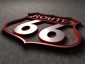
A Guide to Route 66 Through Needles by Maggie McShan
Needles, California
The City of Needles owns its own electric, water and wastewater utilities; consequently the City has the ability to offer unbeatable incentives to relocating business enterprises.
Natural Gas
Needles boasts 10.8 continuous miles of historic Route 66 between the two most outlying off ramps of I-40, except for one brief interruption. The general flow of traffic seems to be from east to west, so exit I-40 just past the California Plant Inspection Station (Five Mile Rd). Drive 1.4 miles to 5 Mile Station where US Hwy 95 separates to head toward Blythe. Continue straight ahead, passing Needles Riverview Cemetery on the left, for 4.5 miles to pass under I-40. Now you are on Broadway, the main street of Needles. Down the hill and to the left, note the ruins of Carty’s Camp, an old cabin court, and nearby the “66 Motel”, still in operation but for regulars only. Continue a short distance to another cabin court, 1930s vintage, once widely known as palms motel, now restored to a bed and breakfast and renamed “Old Trails Inn.” Here’s where Broadway forks with old Front Street. Continuing on Broadway, note historic Women’s Clubhouse on the left, and the Needles borax wagon.
Go on through the main business section, cross Santa Fe Railroad via the overpass, see the historic motel section, then drive beneath I-40 at ‘Q’ street. A few more historic motels will be noted.
Continue on to pass over I-40 at the West Broadway off ramp. This is where freeway construction brought a brief interruption of about .3 miles of the old road. Curve on what is now Needles Highway to where the road forks. Left is Route 66. Right goes to Laughlin, Nevada. At right you will see the river resort areas. Ascend up onto the mesa, pass the KOA Kampground and soon you are at the I-40 entrance.
The freeway (Interstate 40, heading west) covers the route for about 8 miles, but the old road may be resumed again at the exit for Las Vegas/US Hwy 95.
You have traveled 10.8 miles on Broadway, the newer portion of Route 66. The older portion is along Front Street.
Enjoy by entering Front Street at the “Old Trails Inn.” This will lead you past the historic Needles Transfer, the Fire Department and many other historic buildings including “El Garces”, the Harvey House, built in 1906. Train buffs will enjoy this section as it parallels the railroad. It also will take you right by the Needles Regional Museum, located at 929 Front St. Continue around Santa Fe Park past the turn of the century residences on the left and railroad exhibit on the right, to the cul de sac where an early 1960s overpass directed 66 traffic onto Broadway. This section is a total of .9 miles.
Historians realize that the old road was on other streets at other times and research is still in progress. The street officially named “Route 66” extends from in front of the old bowling alley to the KTOX radio station and is .3 miles in length (located on the west side on Needles). Add the Broadway, Front Street and Route 66 logs together and you have 12 miles of the Mother Road that can be claimed.
Route 66 Legend: Maggie McShan
Maggie McShan knows Needles and Route 66 in the Mojave, she should, she came to Needles almost 70 years ago as a young bride. When she got off the train at the El Garces Harvey House she got her first glimpse of Needles. What excited her the most? Why the palm trees of course! The Native Americans and fancy fountain at the depot were a close second. Maggie soon fell in love with the area. Throughout the years she has become quite involved with the historic preservation of our precious heritage. In fact to the roadies of Route 66 Maggie has become a Route 66 icon in her own right. Spending time with Maggie and listening to her stories takes one back to another time along the celebrated Mother Road. I know I relived the grandeur of the old El Garces listening to her words. I love this fine lady!
Route 66 Update: On September 28, 2004 Maggie McShan passed away. She will be solely missed by all who knew her. She did more to promote Route 66, the El Garces Harvey House and the fascinating history of the Needles area than anyone else I know of. Her legacy will live on through all the people she touched along life’s highway.
Route 66 is all about the people like Maggie.
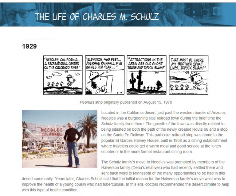
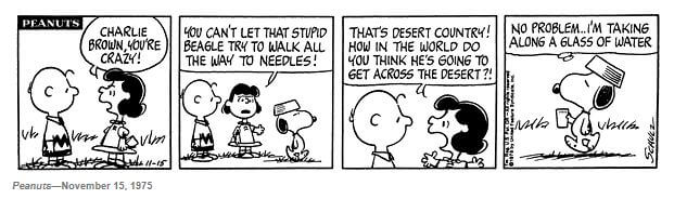
SNOOPY’S BROTHER SPIKE

LIVED IN NEEDLES
In the comic strip Peanuts, whose creator Charles Schulz lived in Needles as a boy, Snoopy’s brother Spike lived in the desert outside Needles. He frequently heads to Needles to partake of the town’s nightlife, often running afoul of the local coyotes.